Last Monday dawned to news of heavy rain and monster commutes. I got an emergency message on my phone warning me of flash floods. My daughter told me that people had to be rescued from their cars on Beach Drive in Montgomery County. So I took a walk on Soapstone Trail and along Rock Creek on Monday afternoon to see how the deluge affected our local streams.
The Washington Post’s Capital Weather Gang reported that some areas of the metropolitan area got between 2 and 3 inches of rain in a very short period of time, causing flash flooding.
By 2 p.m. on April 16th, the downpours had stopped. At least, I hoped they had. As it was, the storm’s impact looked severe. It looked like Soapstone Creek jumped its bed at the trailhead at Broad Branch Road and the culvert.

The rushing water deposited large limbs on what is left of the guard rail at the west side of the roadway.

Heading up the trail that leads to Rock Creek, the water looked high but was within the confines of its bed. But the view changed as I climbed up and then down to the trail that ran next to the creek.
You could see trees standing in rushing water.


Runoff stream beds that had been dry were adding to the volume of the creek.

Only Saturday, volunteers were picking up trash on the Soapstone Trail and other parts of Rock Creek Park. More was washed in.

In another area, the water captured a part of the trail.

The worst of the flooding was at the Park Police station across from the parking lot.

USGS personnel were out measuring volume and taking water samples. And the measuring station at the Joyce Bridge stone shed was collecting data.
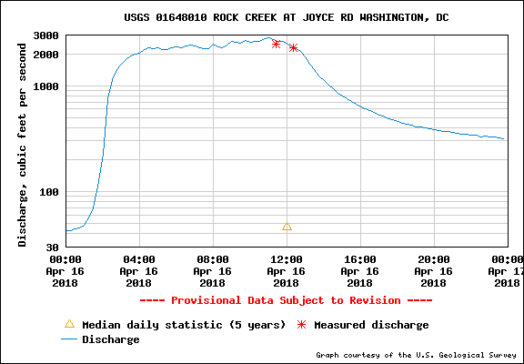
April 16th Rock Creek water flow at the Joyce Bridge measuring station, in cubic feet per second.

The creek did not have the volume found after the July 28 and 29th rain event, and also did not attract the kayakers – too cold, perhaps. Or, too many impediments. At the time I saw the creek there was no room to get under the bridge at Joyce Road.